News

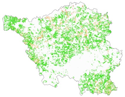
15 years of unbroken relationship with the Saarland

One of our longest-standing customers is the Saarland Ministry of Environment, Climate Protection and Agriculture. The 15-year business relationship includes data processing services related to the Common Agricultural Policy (CAP), now including the latest technological solutions (AI, machine learning).

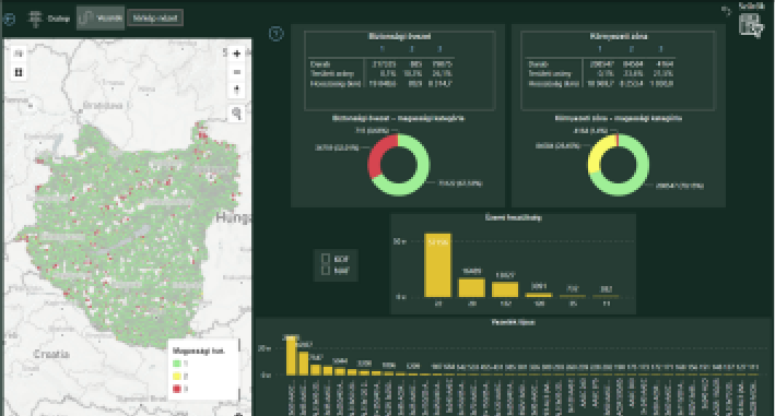
This year’s tasks include the automated determination of the agricultural land use of the province’s agricultural parcels and minimum agricultural activities. The continuously expanding development team and the professional experience of the previous years enable a high level of technical implementation of special and individual tasks of the Saarland, including the previously developed land monitoring technology of GeoAdat Ltd. and the recently developed own mobile application.

We have standardised our development process

Our company has been operating according to the ISO 9001 quality management standard since 2005, and in 2016 we also introduced the ISO 27001 information security standard, since then the two systems have been integrated. To meet the growing and changing needs of our customers, we have extended the scope of the standards to our development activities from 2022. During the audit in November, which already included development, SGS Hungária auditors found that GeoAdat Ltd. meets the requirements of the standard and was awarded another 3 years of certification.

Measurement of the low-voltage network attached to E.On’s power-carrying structures

GeoData Services Ltd. measured the power grids with extensive image recordings in the area of ​​460 settlements, which are supplied by two of the client’s companies in Transdanubia. The task also included the identification of the telecommunications systems mounted on the supporting structures of the power network, and their geoinformatic evaluation of the recordings made on site, then their classification in a database. The work could be performed faster than the deadline specified in the contract, in 6 months with excellent quality indicators of the client.

E.On Vegetation Monitoring System

On November 30, 2021, E.ON Digital Technology Hungary took over the monitoring solution developed by GeoData Services Ltd.: the basic vegetation register and its scheduled regular update, which can be related to the utility’s electric and gas network elements and is produced by satellite remote sensing, started operating. The register contains all the vegetation conditions that can be used to support the management of maintenance processes.

The identification and delimitation of vegetation elements and prohibited activities, which can be identified on the ground, will be carried out in a geo-spatial environment using image analysis software. In order to increase the reliability of the result data extracted from the European Space Agency’s Sentinel group of satellites, time-series data will be analysed (increasing geometric resolution, content identification) in order to increase the geometric resolution and content identification available from each image.

Data publication is done through the online interface of the Vegetation Monitoring System, with modules built from map and business BI elements based on user needs.

New EO project, continuous partnership with ESA

After successful closure of “ORGAN-IM”, we have started our new project under the aegis of European Space Agency’s ARTES Integrated Applications Promotion programme. The “Cert-EO” – Feasibility study on supporting agriculture and food certification by EO-based services” kicked off in early September, with focus on supporting certification of organic farming and detecting of fraudulent agricultural actions in organic sector, built on Earth Observation tools.

In the one-year timespan, a feasibility study will be carried out in cooperation with Organic Services GmbH, to lay down the roadmap of developing a financially profitable and technically sustainable service.

„ORGAN-IM”: Adaptation of European Image Information Mining for the Requirements of Organic and Ecologic Farming in the EU

Our ORGAN-IM project has reached the half-time milestone. The aim of the preparatory activity granted by ESA is to develop a monitoring system that facilitates the control of organic farming with the help of remote sensing.

In the first phase we have built a technology that is based on the comparison of the data extracted from satellite imagery with markers quantifying the deterministic characteristics of the observed vegetation and soil and being specialised to the individual features of organic farming. Monitoring of large areas can be automated through mass data analysis. In November we are going to present the results to date for the ESA experts online. Verification of the developed method is going to be processed in the second phase until the project’s closure in 2021 spring.

EO.TAG research and development project

Our development project „EO.TAG – Demonstrating EO image information mining solutions in mobile imaging domain”, granted by WIGNER ESA Business Incubator Centre Hungary, has been successfully closed. The aim of the activity was to demonstrate the possible usage of technologies and algorithms of ESA SNAP (developed for Sentinel EO processing) in huge mobile image databases of non-space-related end users. We performed mass analysis of the content of numerous site survey images relating to two sectors: public utility infrastructure management and agricultural administration. Relevant participants were involved in the demonstration: ELMŰ and E.ON electricity companies from the utility sector, the German state office LAiV M-V (Landesamt für innere Verwaltung Mecklenburg-Vorpommern, Schwerin, Germany) as an agicultural user and the Italian technology partner, MEEO (Meteorological Enviromental Earth Observation, Ferrara, Italy).

Meeting with Ambassador of Italy

On May 16th the Delegation of Italian Prime Minister’s office had a meeting with the Hungarian Space Clusters committe. The participants was Péter Hargitai chariman, and Gyula Horvath, cluster committe member. The members of the Italian delegation was Stefano Gualandris, Legal and Economic Adviser to the State Secretary of the Italian Prime Minister’s Office, Massimo Rustico, Ambassador of Italy, Teresa Testa, Commercial Attaché, Milan Solymosi, associate / interpreter of commercial office.

Péter and Gyula presented the activities of the Hunspace, and they discussed about the possibilites a partnership in the space industry with italian members in the near future. In closing the italian delegation visited the workspace of GeoData Services Ltd.

Participation in the conference of the Hunspace – “Let’s go tot he space industry!”

GeoData Ltd. participated in the conference of the Hungarian Space Cluster- „Let’s go to the space industry!” – on 29-30. November in 2018. The members of the cluster had the oppurtunity to introduce their companies, and Dr. Orsolya Ferencz, who is the Ministerial Commissioner for space research in Hungary, also took part in the conference. Those members of the cluster, who had already attended in space-related tenders, also shared their experience with the other members.