Category Archives: Egyéb

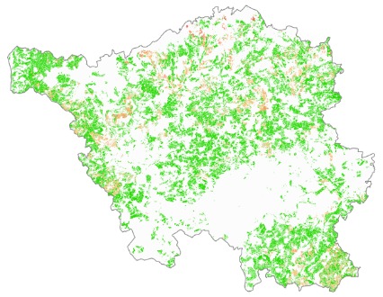
Biotope project for Saxony-Anhalt

GeoData Services has been awarded the EU tender for “Comprehensive updating of biotope type and usage type mapping” for the state of Saxony-Anhalt.

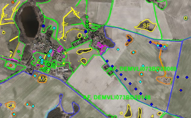
The task is to update the existing map biotope database from 2009 using the aerial photos from 2021-2023 across the entire state (5,465 tiles/Kacheln, which covers 20,452 km 2 ) and to develop the required technology for this update.

The processing is supported by a partially automated development designed for workflows. With its help, the changes between the two states are filtered out by examining the contents of the aerial images and the database (polygons, lines, points) and then transferred to the new database.

Thanks to the technology, the processing is more precise and consistent in terms of content. The new and updated data are entered in accordance with the biotope specifications after checking the content and form. The final database is considered accepted after the customer’s final inspection.

Quality Assurance Planning for Large-scale Network Data Migration

GeoAdat Ltd. has been awarded a third-party quality assurance contract to provide quality assurance support for the network registration system and the migration of the entire masterdata of E.ON utility companies, and to prepare a quality assurance system plan.

A basic requirement for implementation is knowledge of network elements at the data model level and a qualitative approach to analysis. The overall objective of quality assurance is to increase the efficiency and reliability of implementation, to reduce lead times and to reduce costs.

Provision of Base Map Data for Network Inventory Systems

An up-to-date base map register is an indispensable part of the network registration tasks of utility operators.

The base map data is used to build a GIS base database and an address database qualified by manual and automatic procedures. The result is an up-to-date base map register with real data, which supports the productivity and data quality efficiency of day-to-day change management activities, the planning of maintenance tasks, and the provision of authentic data for analysis and queries.

Reference: ELMŰ Network Ltd.

LPIS

Thanks to the good cooperation over the last 6 years and the quality of the service provided so far, GeoAdat Ltd. has again won the tender “Maintenance of the LPIS (Land Parcel Identification System)”, which was launched by the Ministry of Climate, Agriculture, Rural Areas and Environment of Mecklenburg-Western Pomerania for another 6 years in 2023.

The project, which will start in 2024, involves data maintenance of the LPIS. Linked to the LaFIS-LFK system of the German Ministry, more than 420,000 reference parcels (land block, landscape plot, ineligible area) of almost one and a half million hectares of land will be checked at least twice over 6 years.

The project will be carried out by experienced colleagues with a solid background in geoinformatics, cartography and remote sensing, thus ensuring the usual reliable work of GeoData Services Ltd.

Extract from the map data to be checked in the LaFIS-LFK system

More E.ON projects

Vegetation monitoring is just one of our projects commissioned by E.ON. In addition, GeoAdat has been given the honour of assessing, documenting and mapping the data models of two spatially separate but identical grid registration systems.

GeoAdat is also responsible for the periodic change management of the network register data of E.ON ELMŰ Hálózati Kft. and the network register processing and change management of the optical networks operated by ELMŰ Hálózati Kft.

SAT E.ON Vegetation monitoring

The central management of E.ON has carried out a benchmarking study of the solutions of development launched within the group to support the IT support of VM (vegetation management). In the comparison, the Hungarian SAVEM solution developed by GeoAdat Kft. came first in the conventional VM category. German and Swedish colleagues from Budapest participated in the peer review.

Extensive field validation testing was carried out in the summer, the results of which demonstrated the suitability of the system’s data to support VM. E.ON Digital Technology Hungary commissioned the development of the operational level of the system.

AC/DC-EO

GeoData starts a new ESA development (legendary) titled as ACDC-EO, that stands for fully Automated Change Detection of Cultivation via Earth Observation. Several incidents affect our planet’s land cover nowadays. Climate change, that is indicated by temperature rise, flooding, or recent human activities (from natural hazards to military actions) that we are aware of. They all have different and mostly negative impact on agricultural coverage leading to social-economic challenges. GeoData (together with its partners) is working on a technological development for the local, regional and international users community. Future development potentials are identification of non- and under-utilized areas that can be used for the agricultural and/or forage developments.

Enhanced transaction capacity and supercomputer availability

From March, GeoData Ltd. will provide a new, higher level and capacity repository for data processing in projects for Hungarian, German and EU customers. Nearly 600 terabytes are available for short term transactions, and a supercomputer is available for computationally intensive tasks by special arrangement. The “Komondor” supercomputer, which is in operation since 2022, has 5 HPC (petaflop) capacities and includes a dedicated artificial intelligence (AI) and big data partition in addition to a high-capacity processor and graphics computing units.

Happy Birthday, GeoData!

This year marks 25 years since GeoAdat started its activities in the field of geoinformatics with the aim of providing quality services to its partners at home and abroad. During this time we have become one of the most important players in the market, both in Hungary and Germany. We will do our best to continue this trend in the future. Together with our colleagues, we celebrated this beautiful anniversary.

15 years of unbroken relationship with the Saarland

One of our longest-standing customers is the Saarland Ministry of Environment, Climate Protection and Agriculture. The 15-year business relationship includes data processing services related to the Common Agricultural Policy (CAP), now including the latest technological solutions (AI, machine learning).

This year’s tasks include the automated determination of the agricultural land use of the province’s agricultural parcels and minimum agricultural activities. The continuously expanding development team and the professional experience of the previous years enable a high level of technical implementation of special and individual tasks of the Saarland, including the previously developed land monitoring technology of GeoAdat Ltd. and the recently developed own mobile application.